Dec
18
Did the Mount St. Helens Eruption Prove Flood Geology?
“The eruption demonstrated that geologic catastrophe can produce in hours and days geologic features previously believed to have taken millions of years. When we see what the volcano did in such a short time, we can better appreciate how the catastrophe of Noah’s Flood formed the much larger geological features on planet Earth.” — Dr. Tas Walker, PhD, Creation Ministries International (CMI)
The Mount St. Helens volcano in Washington State rumbled to life in March 1980, and in May it finally erupted, first horizontally (which was a surprise) and then vertically. The top and northern face of the mountain was blown off, leaving a mile-wide, horseshoe-shaped crater.
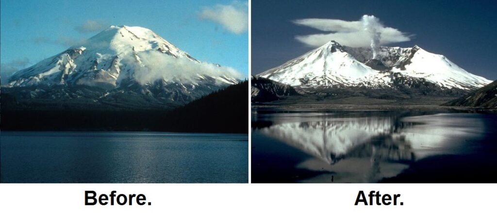
Large-scale death and destruction occurred over 230 square miles (and beyond) due to three major things: 1) pyroclastic flow (i.e., fast-moving current of hot gas mixed with ash and/or other volcanic matter); 2) lahars (i.e., violent mudflows of water, rocky debris, and pyroclastic material); 3) a vigorous plume of ash that blew eastward as far as Edmonton, Alberta. Fifty-seven people died, along with nearly 7000 big-game animals and roughly 12 million fish from a hatchery.
Thanks to numerous smaller eruptions over the following years, a new lava dome formed in the crater.
The eruption and its aftermath, along with supposed implications for modern geology, have been written about by many Young Earth Creationists over the years, but Dr. Tas Walker provides a relatively brief summary of such discussions (and speculations) in an article published in Creation, the July 2017 issue. Walker says,
“The eruption demonstrated that geologic catastrophe can produce in hours and days geologic features previously believed to have taken millions of years. When we see what the volcano did in such a short time, we can better appreciate how the catastrophe of Noah’s Flood formed the much larger geological features on planet Earth.”
In this post, I’ll be taking my queue from Walker to briefly respond to some of his and his compatriots’ claims.
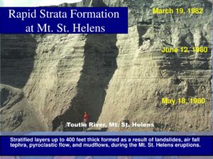
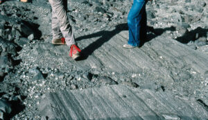
Flood geologists like to point to Mount St. Helens as proof that rapid sedimentation can explain lots of “ancient” formations, including the Grand Canyon. Walker points out that a 25-ft. thick deposit of finely-layered sediment, which can be seen in the cliffside along the North Fork Toutle River, was witnessed to have formed over a three hour period on June 12, 1980. The cause was pyroclastic flow from Mount St. Helens’ second major eruption, racing along at 100 mph. Conventional wisdom would expect a high-speed ash flow to result in a well-churned mix rather than fine laminae, which should take hundreds of years to accumulate. “Mount St Helens showed that the coarse and fine material automatically separated into thin, distinct bands, demonstrating that such deposits can form very quickly from fast flowing fluids (liquids and gases).” Subsequent lab experiments show that the same happens with water.
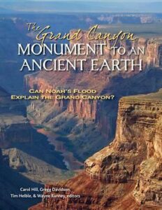
In response, I point to the following comments from Stephen Moshier and Gregg Davidson (The Grand Canyon: Monument to an Ancient Earth):
“Geologists have long recognized that natural processes can be slow (like coral reef growth or deep ocean sedimentation) or fast (like volcanic ash deposition), though some geologists of the nineteenth century tended to think that most of the Earth’s rocks represented slow processes. Today, uniformitarian geology recognizes that there are many places and times where catastrophic events have contributed to shaping the Earth’s varied layers, and that the physical conditions on Earth, such as the chemical makeup of the atmosphere and oceans, have not always been the same as they are today….
This comparison of modern deposits to ancient deposits is a fully uniformitarian exercise — the present (Mount St. Helens) is the key to the past (Grand Canyon). In this case, however, as in many other examples, flood geologists are not consistent in comparing apples with apples and oranges with oranges. The formation and behavior of volcanic ash layers cannot be directly compared with the formation and behavior of sandstone or limestone. The rocks in the Grand Canyon are made of entirely different material from ash, and the immense size of the canyon’s vertical cliffs (much larger than those found at Mount St. Helens) clearly testifies to the fact that the cliffs were already hardened to rock before they were cut by the Colorado River.”
That last sentence leads into Walker’s next topic. He writes, “The Mount St Helens eruption also demonstrated how canyons can be formed much faster and in a different manner than conventionally thought. Ongoing eruptions eroded the thick sediment dumped at the base of the volcano, producing multiple channels and canyons.” One of the examples he gives is the ‘Little Grand Canyon’ (140 ft. high, up to 150 ft. wide, with a small stream running through it), which was “carved by a mudflow caused after a small eruption of Mount St Helens melted snow within the crater on 19 March 1982. The mud built up behind debris, burst through it, and cut the canyon in a single day.” Walker also points to the Loowit and Step Canyons as examples of mudflows taking only months to “cut through solid rock, including old, andesite lava flows.”
For a non-YEC response, I turn to Moshier and Davidson’s co-authors, Tim Helble and Carol Hill:
“When Mount St. Helens erupted on May 18, 1980, nearly a cubic mile of hot pumice rock, ash, and eruption debris catastrophically slid off the north face of the mountain and filled the valley below. About 22 months later, a smaller eruption melted the deep snow in the mountain’s new crater and sent a large flash flood of water and mud rushing into the North Fork Toutle River Valley. This flash flood immediately began cutting a new network of channels into the loose, un-cemented ash, rock, and debris left in the valley by the 1980 eruption.
These rapidly formed canyons are offered as evidence supporting rapid formation of the Grand Canyon, but little attention is given to anything other than how fast they formed. The numerous, U-shaped, small canyons and gullies cutting into the loose material below Mount St. Helens do not look anything like the single, massive, V-shaped Grand Canyon. As vertical walls formed in the Mount St. Helens ash, the unsupported ash slumped and dropped piles of loose material down into the stream channels. In great contrast, the Grand Canyon walls remain vertical at heights of hundreds of feet, with no evidence of slumping and no piles of un-cemented and splattered sediment at the base of the cliffs. The striking differences between Mount St. Helens and the Grand Canyon provide strong evidence that the Grand Canyon layers were rock when they were carved, not soft deposits like those from Mount St. Helens.”
Walker mentions that grooves and scratches in large rocks are typically blamed on glaciers moving slowly over them over long periods of time. But, “grooves in rocks at Mount St Helens… were gouged by fast-moving rocks propelled by geological catastrophe, not a slow-moving glacier.” He doesn’t mention if this was actually documented or if the grooves have a fresh-cut vs. worn appearance. I didn’t find anything in my books or in a quick search online that addressed this particular claim, but it seems hard to believe that non-YEC geologists don’t recognize other means of such grooves and scratches forming, such as by landslides (like during the Mount St. Helens event, presumably). Am I missing something here? Or, is it another instance of YEC scientists misunderstanding or misrepresenting common geological assumptions or methodology?
Another favorite “proof” for Young Earth Creationists is the existence of polystrate trees, often fossilized (as in Yellowstone National Park). These trees are in a roughly upright position and penetrate multiple sedimentary layers. The YEC explanation is that this happens in a quick burial by naturally-layering flood deposits. Walker brings this up in his article, though it is in the context of explaining “ancient” coal and forests (which I’m not going to get into here).
After explaining how landslides and mudflows from the Mount St. Helens eruption stripped trees from the local forest, Walker says that a small portion of the landslide fell into Spirit Lake, causing an 860 ft. high wave to wash up the opposite hillside and drag millions of large pines into the lake. The resulting “log mats” sunk to the bottom and eventually tipped vertically. A similar occurrence happened miles down North Fork Toutle River. Walker says,
“In the past, geologists routinely said vertical tree trunks entombed in sediment were buried where they were growing… buried multiple times over many tens of thousands of years…. Geologists now know that trees can be transported into place by volcanic catastrophes and left sitting vertically, as we saw at Mount St Helens.”
However, in his A New Look at an Old Earth, Don Stoner observes,
“In the first place, sedimentary layers do not necessarily take millions of years to deposit, nor do scientists believe they do. The layers in the Green River Formation, for example, were each produced in a single year (although the whole formation certainly took millions of years). For another example, each layer in a floodplain deposit is the result of a single flood event. Floods can come in fairly rapid succession and deposit a large amount of sediment very quickly. Although young-earth creationists often talk as if they were the only people who believe in floods, they are not. All scientists believe in many big and little floods. Noah’s flood left sediments, but so did many other floods. Polystrate fossils were not all the result of Noah’s flood; in fact, most were the result of other prehistoric floods or rapid sedimentation events.”
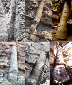
Here are a few other points worth noting: 1) Floods are not the only ways trees can be buried; volcanic ash and rock can descend on forests, burying them a few feet deep. This kills the trees, exposing the top portion to slowly rot away while the lower portion eventually fossilizes. The ashen surface weathers into soil, new forest grows, the volcano eventually erupts again…. 2) Extensive field research by Dr. Richard Ritland — a Seventh Day Adventist, that sect which came up with modern “flood geology” — led him to conclude that the YEC transport theory for the origin of fossil forests does not jibe with the facts. 3) Christian geologist William J. Fritz conducted a detailed study of fossilized forests, which he presented in a 1972 paper. He found nothing to support “flood geology”, though he did find evidence that some upright stumps had slid down a mountainside to their final resting positions.
Finally, Walker seems to have tacked on an earlier, short article about radiometric dating. We all know that YECs are highly dubious about the reliability of radiometric dating. YEC geologist Steve Austin visited Mount St. Helens in 1992 to get a sample of the new volcanic rock (“dacite”) composing the new dome. Since we know when the dome was formed (1980-1986) and therefore its age, this was seen as a unique opportunity to accurately test conventional, radiometric dating methods.
“After preparing a collection of different sub-samples, Dr Austin sent these to a reputable commercial laboratory to make measurements suitable for the potassium-argon method of ‘dating’. Some subsamples were prepared of the whole rock while others were selected to emphasize different minerals making up the rock [e.g., hornblende, pyroxene]…. The calculated ages of the rock from the lava dome ranged from 350,000 years to 2,800,000 years, yet the rock had formed just 10 years before. Clearly the ‘age’ was vastly wrong…. Some people have objected that the tests were inappropriate because the potassium-argon method only works on rocks that are millions of years old. However, the plus-and-minus range (±) against each result cancels that objection.”
Here is a relevant excerpt from the Grand Canyon book, this time by Roger Wiens:
“Thousands of rock samples are dated each year, and in the vast majority of these cases there is agreement among different dating methods, and among rocks in the same area, presenting a clear picture of the old Earth.
Although ample tests have been done to confirm the accuracy of radiometric dating, some flood geologists still claim that radiometric dating gives inaccurate or irreproducible results. A popular example of this claim involves Mount St. Helens in Washington, which erupted in 1980, sending volcanic ash flows racing down the mountainside. In 1986, a fresh cone of magma growing in the crater was sampled by Young Earth advocates and submitted for dating. A potassium-argon date of 300,000 years was calculated for this sample, which is now repeatedly featured in flood geologist lectures, videos, field trips, web sites, and museum exhibits as evidence against the reliability of radioactive dating.
However, two critical pieces of information are left out. First, it is common for fragments of old rock from the subsurface to become entrained in the upwelling lava. Indiscriminate sampling of the lava could very well result in a mixture of new and old rock, yielding an age much older than that of the lava flow. The second piece of information left out is that the dating technique used (potassium-argon) has long been recognized by geologists to yield inaccurate results for recent lava flows — not because ‘they don’t give the right answer,’ but because of known processes at work in this environment. Methods such as argon-argon dating take these processes into account, and do in fact yield reliable ages (such as accurately dating the Mount Vesuvius eruption mentioned above). Radiometric dating techniques are accurate. This has been proven over and over again.”
[Note 1: My guess is that Dr. Wiens is referring to a previous visit (1986 vs. 1992), but his response still applies.
Note 2: Walker actually finished with a second attached article, this one titled, “The Hummocks demonstrate previously-unknown volcanic hazard”. But, I didn’t have time to dig into it.]
There you have it. I think Wiens and the others did very good jobs countering the YEC claims by Walker and his fellow YECs / flood geologists. I hope you have benefited from this presentation of the information, though the “conversation” is certainly not over. I would love to see a friendly debate on this stuff between, say, Walker and Austin vs. a couple of the Grand Canyon contributors. (Not to be confused with Austin’s book, Grand Canyon: Monument to Catastrophe.)
(H/T the multiple authors of Grand Canyon: Monument to an Ancient Earth, and to Don Stoner, Davis Young, Alan Hayward, Hugh Ross)